August 6th
Klesilkwa Mountain
I've been in the mood lately to explore isolated areas. This adventurous spirit started with Alpaca peak. I was hoping it would be a bushwhack, but in my opinion, it was far from it. Therefore, I was still searching for this exclusive bushwhack up a rarely traveled mountain. So once again, I opened up Google Earth. This time I looked a bit further than before. I had never hiked East of Chilliwack lake, so I was curious to see what was out there. Klesilkwa mountain caught my eye, mainly due to its unique name and its 2075m elevation. I searched the clubtread forums for trail reports and only found a handful of trips up to its peak. I've finally found the elusive ultimate bushwhack that I've been searching for. (Oh, and was it ever!)
Being a bushwhack, there's no official trailhead for Klesilkwa. Based on the research I did, I was planning an approach from Klesilkwa S1's South slope, and conquering both Klesilkwa S1 and Klesilkwa itself. I drove down Chilliwack Lake Forest Service Road until it intersects the Trans Canada Trail (formerly Paleface Creek FSR). From past reports, I knew Paleface Creek Forest Service road was nearly impassable, so I wasn't sure how much further I would be able to drive. Furthermore, now that the FSR was part of the Trans Canada Trail, I assumed it had now been deactivated as a forest service road. Therefore, I really wasn't sure of the rules behind driving on it (If anybody knows, let me know!). Skeptically I still tried to drive my Jeep up the trail a little. I traversed a handful of cross ditches that were steadily worsening as I got further in. The trail also started to narrow, looking more and more like an overgrown FSR that hadn't seen a vehicle in years. I decided to just turn around and park along Chilliwack FSR at the TCT intersection. Now I was looking at an extra 5.2km walk each way to the start of my bushwack. That wasn't going to stop me, I was determined.
 |
| An approximate drawing of my route. The blue is my walk on the Trans Canada Trail. The red is the unmarked bushwhack section. |
 |
| The sign marking the start of the TCT, featuring my specialty finger in the lens. |
After walking for just over an hour, I made it to the area where I wanted to start bushwacking. The walk to this point was easy with just a slight incline. Even If I would have tried driving further, I wouldn't of made it to my "trailhead". There was one mighty cross ditch/creek crossing that would of been nearly impossible even if you had a lifted Jeep Wrangler.
 |
| Early portion of the TCT, I knew at this point that this wasn't for vehicles anymore. |
 |
| Half way up the TCT the forest started to open up a little while approaching old logging activity. |
I decided to start my hike up Klesilkwa by climbing through an old logging clearing. Whether or not this was a good idea is something I may never know. It was a hell of a time going through the new growth of mostly prickly plants and tall "weeds". I wore a long sleeve and pants because I knew it would be a tough go, but man oh man, my patience was tested. Not to mention the plants were chest high, so finding footing was nearly impossible. I really wish I would of took a picture of this part but I was too busy contemplating just turning around and going home.
 |
| A picture just before the corner where I started my bushwhack. The vegetation in the clearing was similar to this, |
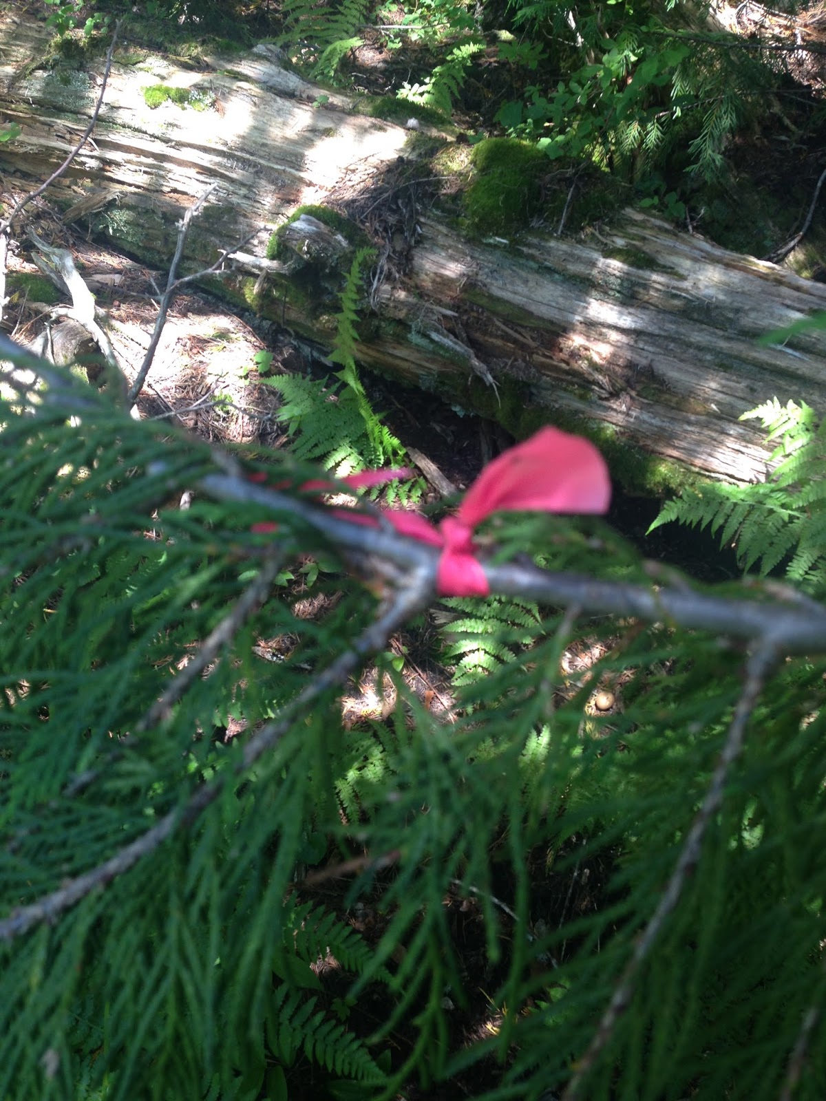
The steepness was brutal, but that was expected. I hadn't planned any switchbacks, just a straight up grind. I decided to follow the general route of a gentleman name Elkaholic on clubtread (
Elkaholic's forum post), but instead I chose to start 50-75m to the East of his start. The fact that I was so close to his approach left me to believe that the three random pieces of marking tape I spotted along the way were his. All there was left of them was the knot on the branch. They were so few and far between I laughed in disbelief when I stumbled upon them. Out of all the lines up to the ridge, I was walking in the same general direction that he may have taken over 9 years ago. Those three ribbons were the only signs of humans I spotted the whole way up.
 |
| A view of the paleface creek valley containing the Trans Canada Trail I took to get here. |
 |
| Finally at a height where I can draw motivation from my surroundings. Easy to see all the old logging roads. |
 |
| One of random little piece of marking tape I've found. No sign of a trail, I'm surprised I even found this. |
 |
| It sucks wearing a long sleeve when it's warm outside. |
 |
| Lunch break location - Looking Southwest at Mt.Lindeman, Macdonald and Webb. |
 |
| A panoramic view of the south - The Paleface Creek valley is in the dead center. A view like this and I'm still not at the summit. |
It took me an hour and a half of bushwhacking (2.5 hours from the car), including a lunch break, to reach the summit of Klesilkwa S1. It can be done much quicker considering I stood there contemplating whether or not to continue multiple times while I was in the clearing. The views on S1 were awesome, it was a view of the surrounding mountains like no other I've ever seen before. I totally new perspective of the Chilliwack River Valley, I love it. I was able to recognize familiar peaks and point out the ones I've been up.
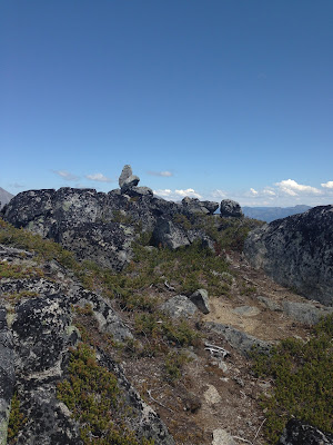
 |
| Klesilkwa S1 summit cairn...if you even call that a cairn. |
 |
| Another view of the southern view, looking into states. |
 |
| Southeast view - Mount Redoubt's peak is just hiding in the clouds in the center of the photo. |
 |
| A panoramic view from Southeast to the Southwest. |
 |
| Klesilkwa S1 - A potentially nice camping spot if you're willing to brave bringing a big bag through the dense bush. |
As I looked North from here, I saw my destination; Klesilkwa Mountain in all its glory.
 |
| The beast I came to conquer. |
I was terrified at this point. By looking at how steep the mountain was, I wasn't sure if I would be able to climb it. I started to wonder how the hell previous explorers made it up there. I figured I would at least get a closer view of what I was dealing with, so I traversed the col to the base of Klesilkwa. From that point on, I scrambled my way up the easiest path I can find. Based on the scat I found, I was on mountain goat trail. This discovery had me extra motivated to get to the top. I even started exploring around hidden corners to see if I can find any goats, but none were found. :(
I did however find fresh markings of goat activity at the summit.
 |
| My route to the top looked something like this. |
 |
| I had gotten this far, I was going to find a way up. |
 |
| Hard to see, but this was incredibly steep. |
Just 45 minutes after leaving the summit of S1, I made it to the top of Klesilkwa. I would finally get to see my prize, the prize that dragged my butt all the way up here. It was a no name lake on the Northwest side of Klesilkwa. It had beautiful clear, dark blue tint with a tad of emerald. All the pain and struggle of the steep ascent had gone away and I was finally in my happy place once again. I sat there and snacked as I gazed around admiring the views. Like every other hike I've done, I added a handful of mountains on my to-do list! :)
 |
| Mountain goat markings? This was actually a large area. I was thinking that a mountain goat might have been laying here not too long before I got there. It was so fresh, I was able to see the moisture from the recently moved dirt. |
 |
| I MADE IT! |
 |
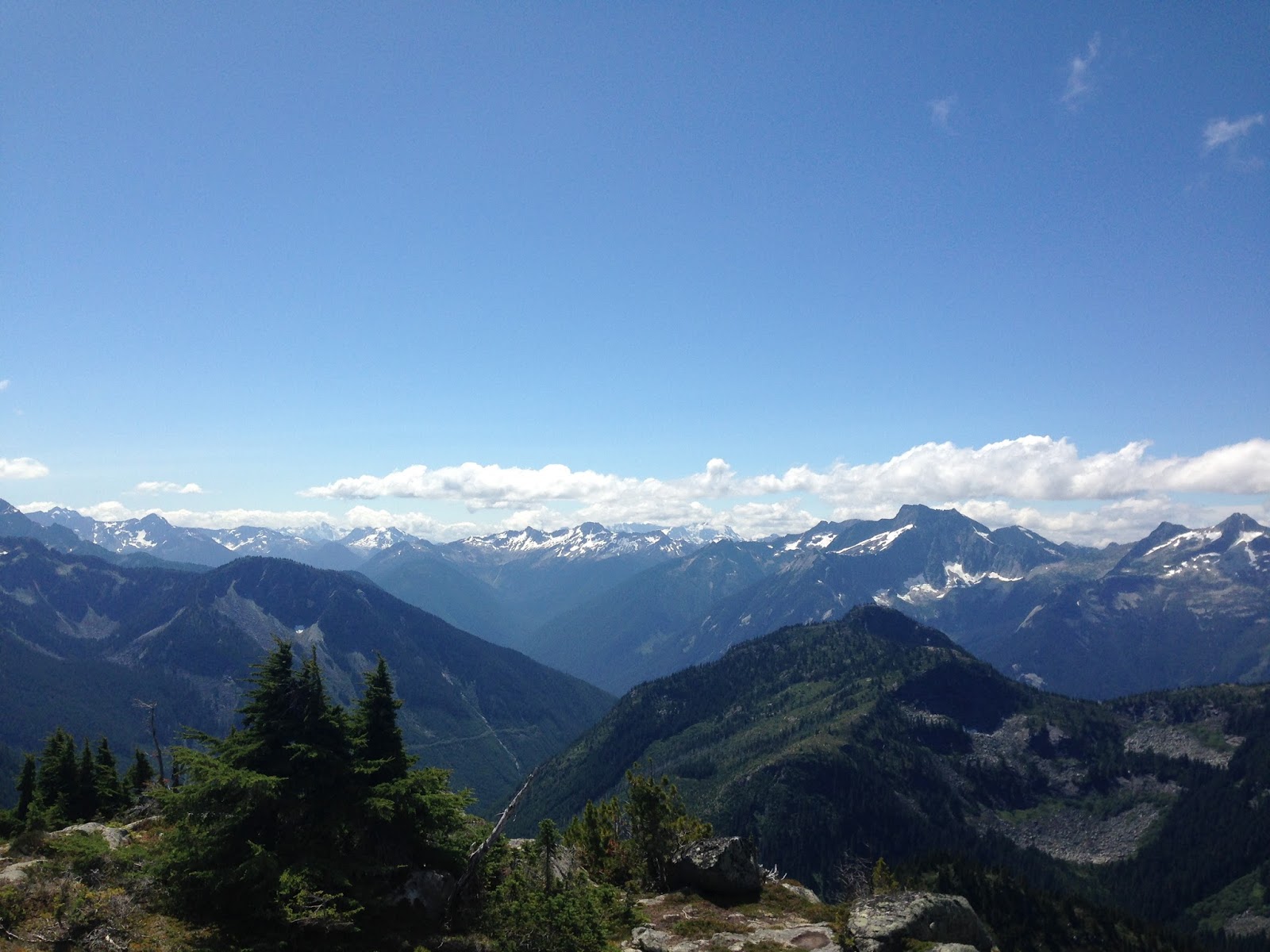
| Another pano to the South. It was by far the best view. |
 |
| View to the North - Starting from the right, Silvertip, Rideout, Sumallo and Payne among others. Silvertip and Payne are both on my to-do list now. |
 |
| View to the East |
 |
| THE LAKE! |
 |
| The prize of this hike. Based on pictures, I was expecting an emerald tint like Garibaldi lake (possibly different depending on the time of the year?), but this worked. In person, the blue of the lake was such a contrast to the surroundings that it hurt the eyes. |
 |
| The view to the Southwest overlooking the summit cairn. Add another mountain to my bag! The mountains in this view are the mountains that border the south side of Chilliwack Lake Road. |
 |
| If you're brave enough to do the descent on the North slope of Klesilkwa, you can venture to this unnamed mountain where you can get a view of Clerf lake down below. Unfortunately from Klesilkwa, Clerf lake is hidden away. |
 |
| Looking back from where I came from -Klesilkwa S1 in the near center. |
From this vantage point, I was able to see mostly every mountain I've climbed. The geology of this region was fascinating. Being between the Chilliwack River valley and the Coquihalla Region, I started to notice features that were dominant in each of their respective areas. I deemed it somewhat of a hybrid region. I'll have to do more hikes in the surrounding area to explore these features in more details. I also need to find some kind of course somewhere so I can delve deeper into the world of rocks and mountain formations. If anyone knows of good resources, please let me know.
 |
| The struggle of life atop a mountain. |
One would think the way down would be easier, well let me tell you...it wasn't. It may have been if I would have taken the same route down, but who the hell knows where that was. Once I got back to Klesilkwa S1, I started my descent much more East on the ridge that I came up. I chose this path because of a rock slide clearing. Unfortunately, that lasted 10 minutes and I was now stuck in some of the thickest bush I had ever seen. My bag was getting stuck on each branch as I plowed and ducked my way through. There wasn't many happy thoughts in my head anymore. From this point, I started heading West instead of straight down, and a few minutes later I was out of the super thick stuff and into normal bushwacking; dense, but passable. Eventually I got back into the clearing and I zigzagged my way down. The footing was even harder on the way down.
Once I got back on the Trans Canada Trail I jogged the remaining 5.2km to the car. At that point, I just wanted to get home. In total, the hike took just under 8 hours and was approximately 17km long.
If you're not a fan of bushwacking or being in complete isolation, don't even bother thinking about approaching Klesilkwa. It was probably not the best idea to do this hike alone. The risk of injury was quite high. It wasn't a very dangerous hike, not much exposure. mainly just bad footing leading to a lot ankle breaking possibilities. Unfortunately no wildlife was spotted. When it comes to bears, that's a good thing, but I would have enjoyed to see a mountain goat.
All in all, the views are amazing, but was it worth the struggle to get there? I can't decide. I'll let you decide for yourself. I definitely don't plan on returning, but I'm glad I did it once. It would be awesome to know how many people have ever been on top of this mountain. I feel as though it is a select few. Who's next to join the club?
As always,
Get out there, have fun and stay safe!
Cheers,
Eric Boudreau


Comments
Post a Comment