Mount Baker, the largest mountain in all of the North Cascades, visible from nearly every peak in the region, is truly an adventurers paradise. Not only is Baker visible from many peaks, it is also visible while driving east on highway 1 from Vancouver to Chilliwack, looking especially magnificient as you approach Abbotsford. What many people may not know is that Mount Baker is actually a stratovolcano, not to mention, an ACTIVE volcano. I knew for a while now that it was a volcano, but until our visit to the area, I had no clue it was active. I spoke with a local while stargazing one night near Artist Point and he mentioned that if you look closely during the winter, you can see Baker releasing steam from its volcanic vents. Not to say I didn't believe the man, but as soon as I got home I hopped on google, and sure enough, he wasn't lying.
As I mentioned, Mount Baker is a stratovolcano. Therefore, it was built by multiple layers of lava and ash bubbling up from the ground, giving it its distinct shape as we can see in the images below.
 |
| Mt.Baker viewed from Artist Point after sunset. |
(PS. I'm going to spew out a few more history facts here because I'm really fascinated by it all. If you prefer, you can scroll down to skip to the trail report.)
The last major eruption of Mt. Baker was 6700 years ago. Baker was created due to the subduction of the Juan de Fuca tectonic plate and it is actually the youngest volcano of a volcanic field that has been active for 1.3 million years. Baker has been under the microscope a lot since 1975, a year filled with activity deep inside the "sleeping" giant. During the winter months, a few adventurers noticed a dark column of smoke staining the snow of the Sherman Crater glacier. This was quite different than it's usual white steam emissions. Scientists confirmed these findings, noting that there was a ten fold increase in thermal activity, raising concerns of a possible eruption. Luckily, Mt.Baker quieted down and a eruption was avoided, with only new vents and melted glaciers leaving place to new landscapes soon to be covered with snow once again.
For more information, volcanic history and interesting pictures please visit:
https://volcanoes.usgs.gov/volcanoes/baker/
All the above information was taken from this website as I tried to give you guys a quick summary.
Trail Report
On to the fun stuff now. I've been wanting to explore this region for the past year, getting up close and personal with Mt.Baker was a must. Finally, Stella and I decided to make a weekend trip out of it. With two hikes, possibly three, in mind - Skyline Divide, Heliotrope Ridge and Ptarmigan Ridge. We ended up only doing the Skyline Divide and Heliotrope Ridge, and I would recommend them both to everyone.
Day 1 - Heliotrope Ridge
We left my place at 8am Saturday morning (July 23rd, 2016), arriving at our rental condo shortly after 10am. With no stops, the drive would have been just over an hour, but the border crossing was painfully slow. We stayed at the Snowline Lodge, perfect for hikers. I was really pleased with our little condo, which also had a kitchenette included. A great location and the best price I can find in that area. For that reason, I am gladly recommending it to anyone planning on heading out that way -
https://www.mtbakerlodging.com/snowline-lodge/
After quickly dropping off our baggage we headed out to do Heliotrope ridge, a 5.5 mile round trip hike to the Coleman glacier. There's multiple signs to get to the trailhead and the road is in decent condition. It is a paved single lane road all the way to the trailhead, accessible by any car. Being a mountain road, there's lots of wear and weathering, which turns into potholes, but nothing you'll lose a wheel in. 8 miles off the highway, you'll arrive to your destination.
*Don't forget to pick up your forest pass at the Glacier Public Service Center*
As we walked up to the trailhead, we noticed that every car had a paper on their dash or hanging from their mirror. Sure enough we saw a sign saying "forest pass required". Going back to get a forest pass would've added at least an hour to an already late start to the day, so we decided to risk the consequences and hike anyway. Luckily we didn't get caught and the next day we went and bought a pass.
Being 5.5 miles long and a moderate steepness, I would consider heliotrope ridge a beginner-intermediate hike up to the glacier. If you want a higher view of the glacier, hike to the base Mt.Baker. It's still easy, but steeper and shaly.
 |
A reminder that you're in paradise...as long as the volcano
doesn't |
 |
| You might have to pay to access the area, but the trails are definetly well maintained. Trail workers were even out there on the weekend. A big thank you goes out to them. |
Our day started off in the clouds. Fingers crossed, we hoped they'd be gone by the time we made it to the base of Mt.Baker. It's guaranteed that you won't be alone on this trail, it is extremely popular. We sped by groups of all ages and capabilities. The only majors challenges along the way were a few creek crossings, the second one especially being quite tricky. Depending on the season, I'm sure the second creek can be almost impassable.
 |
| A picturesque creek just seconds onto the trail. A bridge is used to cross this one. |
 |
| The first creek crossing - It opens up a bit out of the picture where you must cross. Nothing hard, just slippery rocks. |
 |
| The second creek crossing - I'm trying to find the easiest way across, while avoiding getting my feet wet. |
Once you get out of the bush, the view opens up and in between clouds baker started to show itself. From this point, you have a few little creek crossings and one final push to the ridge.
 |
| The first view of baker. This picture was taken on the way down as Baker was covered in clouds on the way up. |
 |
| Little friend wondering who these strange people are. |
After about an hour we reached the ridge and the first view of the glacier. I can pretty confidently say that both Stella and I's jaws dropped. It was stunning, like nothing I've ever seen before, the Columbian Icefields being the only comparable thing. But this, this was totally different. You can hear the glacier thundering as pieces broke off while it flowed downhill at a snail's pace. I'm trying to find words to describe it, but I can't, it was simply amazing.
 |
| The first view of the glacier, aka, the first photoshoot. |
 |
| A closer look shows a group of ice climbers practicing at the base of the glacier. Maybe that'll be me one day? |
A 20-30 minute walk up the ridge gets you at your final destination, unless you're willing to continue up into the snow. I wouldn't recommend taking that risk though, you never know how solid the snow really is. At this point my only thoughts were: Glaciers are mesmorizing.
 |
| Nature's wonders. |
 |
| That moment when all the hard work pays off. |
Oddly enough, the highlight of my hike wasn't even the mountain views. It was the mountain goat I spotted at the top of the ridge. I've been searching for a mountain goat since my family trip out west in 2006. We had visited multiple spots in hope of seeing mountain goats and never did. Finally, 10 years later, almost to the day, I have spotted my first wild mountain goat!!! :D
 |
| The one and only, Mr.Goat. |
More info on heliotrope ridge:
http://www.wta.org/go-hiking/hikes/heliotrope-ridge
Day 2 - Skyline Divide
Day 2 was an early morning start. Knowing that the Skyline Divide is a 9 mile round trip hike, we knew we would want to get out to the trailhead early, especially since we were hoping to explore onward towards Hadley peak. The road to the trailhead is single track and has many blind turns and potholes, which makes the 12 mile drive quite long. Cautious driving is recommended, which means, don't drive like a maniac like me.
Here's how to get to the trailhead:
This trail is quite popular, therefore you won't miss the trailhead, as there will be several cars parked.
After only 2 miles (45minutes) of hiking we reached the ridgeline and once again the views nearly knocked us on our butts. Mt. Baker looked HUGE. Combined with a absolute beauty of a day with no clouds in sight, I knew it would be an amazing hike. Already I was able to see the Cheam range, Mt. Mcguire and other known Canadian peaks that I've already conquered. I love looking at the skyline nowadays and being able to point out all the peaks I've been up.
 |
| First view of the day. |
 |
| I see you Cheam range. |
The next 2.5 miles of the hike are all along the ridge, as you hike up and down the multiple knolls. From this point on, it's not very challenging. A few of the knolls are a bit of a grunt, but your adrenaline will be so high you won't even feel a thing.
 |
| Baker with no knolls in the way. What a beast. |
 |
| The cairn that marks the end of the Skyline Divide. |
 |
| A look back at where we came from. Quite cool to see. |
Once we reached the "Summit" cairn, we decide to push on. It was still early in the afternoon, so we were going to see how close to Hadley peak we can get.
I can walk on this ridge forever. It was awesome, the landscape was so similar, yet so different from the mountains in the Chilliwack river valley. It seemed like every mountain here was interconnected by open alpine ridges with amazing views.
 |
| Stella trekking along. |
 |
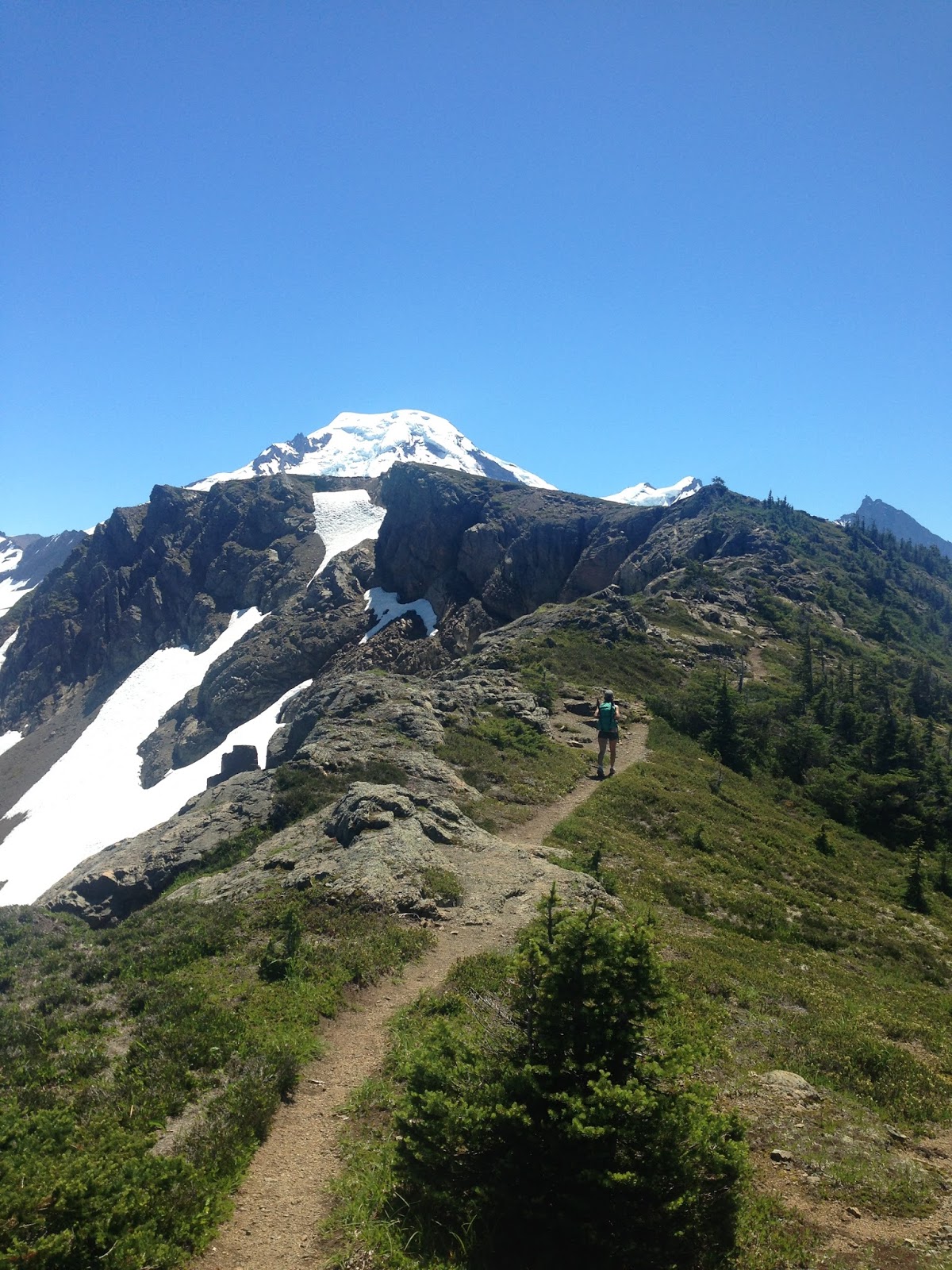
| One step closer to Baker, many more miles to go before reaching Hadley peak. |
 |
| Our final destination - A beautiful view of Baker and it's glaciers. |
We followed the trail down from the skyline divide towards Chowder Ridge. We continued on for over an hour before reaching a knoll followed by a sketchy crossing to attain Chowder Ridge. We decide to stop atop of this knoll with views that didn't disappoint. I couldn't spot a trail from this point on. I was able to see a trail on the ridge in the distance, but I had no idea how to cross the exposed steep ridge ahead of us.
The way back was a long one. The sun had sucked out all our energy. I don't really know our total mileage, but we hiked for a total of 6.5 hours.
All in all, this was a weekend to remember. I would with no doubt recommend these two hikes to anyone visiting the Mount Baker National Forest. I had such a great time seeing the glaciers, the mountain goat and the always beautiful Mt. Baker. I was sad to leave but I knew I'd be back. In this case it will be this fall, where I plan to do the Yellow Aster Butte, supposedly a must do hike during the fall.
 |
| Last but not least, a little bonus image Stella took of Mt. Shuksan at Picture lake near Artist Point. |
(I apologize for the lack of blogs lately, I've fallen so far behind that I've been almost dreading catching up... but here I am trying to claw away at it.)
Until next time my wonderful readers!


Comments
Post a Comment