Sometimes Failure Is A Good Thing (Mt.Grant)
First of all, before I start, I would like to remind everyone that knowing your limit when hiking is extremely important. Keep reading and you'll understand why I wanted to get that out first. Let's begin.
Following a fairly dry month of April, May has been a much more rainy month, especially on weekends (just my luck). The rain has left me twiddling my thumbs at home, wondering what to do. Like many people, I hike for the views. Drudging my way through water and mud on a cold rainy day is not my thing. All that work just to be standing in a cloud at 2000m+, barely able to see where you wear 5 minutes ago, that's not very rewarding. It's time to put all of that behind us now. June is here and finally, and I mean it, FINALLY... a SUNNY weekend. Although, 36 degree celsius is kind of hot....or maybe I just like to complain. ;)
Now that I finally had a nice weekend, I had to figure what mountain I wanted to climb. Not only did I have to pick one, I had to do some research on their recent conditions. Turns out, most of my favorite peaks still have too much snow to safely summit. At this time last year, I was standing at the peak of Mount Macfarlane. Although, one must not forget, the snow pack last year was ridiculously light, shattering records in many parts of western Canada. That meant, at this time last year, multiple big peaks (2000m+) were safe to explore. But maybe this was a blessing in disguise? I was forced to dig deeper and find a new peak to explore. BOOM. Mount Grant.
It was 7am on a beautiful Saturday morning, I woke up with the sun shining and the birds singing their beautiful songs...just kidding, this isn't a fairy tale, this is not how it's going to work. It was actually just before 7, the birds' chirping woke me up, so I was grumpy and I just wanted to sleep some more. I dragged my ass out of bed because I knew I would be mad if I didn't get a hike in today.
It was approximately a 50 minute drive to the trailhead. Here's a map with directions on how to get there. By clicking on more options, you can get edit the start point to wherever you would like.
As you can see, Mount Grant is located just north of Eaton lake. Consequently the same trailhead is used for both. The trail for Mount Grant splits off right before you get to the lake, at a debris pile in the outflow, just before the campsite. Eaton lake is definitely worth hiking to just on its own. If you're willing to hike up with a bit of weight, Eaton is definitely a lake where you can bring an inflatable tube or paddle board and float around in the sun all day. On top of that, there's always many overnighters, there's few campsites at the lake that I think would definitely be worth it. The view at the lake will quickly make the 3 hour struggle up vanish from your memory.
For additional information on how to get to the Eaton lake (Mount Grant) trailhead, you can consult http://www.clubtread.com/routes/Route.aspx?Route=18
To make it short and sweet, as we can see in the map above, the trail begins just over 16km down Silver Skagit road near Hope, BC.
Not too far in, the trail turns into your typical single track hiking trail and the grind begins. Luckily, the trail stays in close proximity to Eaton creek all the way to the Eaton lake. Therefore you get amazing views of the very fast flowing creek with small waterfalls scattered all along it. A photographer's heaven.
After a brief moment of pure joy it was time to begin grinding again. After the waterfall, the trail becomes very unforgiving. Switchback after switchback you start zigzagging your way up to Eaton lake. There's many bridges along the way that add a lot of character to the trail. I can assume that these bridges have been the centerpiece of many photos. I say that with confidence because I rarely think of taking photos and I had the urge to snap a picture of them all.


I wish these bridges can talk because I'm sure they would have killer stories of people slipping and falling into the creek below! *insert evil laugh*
Midway up to Eaton lake, I realized that my fitness level really was nowhere near what it was at the end of last summer. My lungs were burning, my legs were aching, but stubborn as I am, I still refused to adjust my pace accordingly. (*Hint of things to come*)
This was my first big hike of the season and Mount Grant would prove to be no easy feat.
After a grueling hour and a half of pushing myself full tilt up a 22.3% average grade, I made it to Eaton lake. One of the most stunning lakes in all of British Columbia (in my opinion). THOSE VIEWS!!!
I quickly snapped a few pictures and then off I went to search for the split in the trail that leads to Mount Grant. I had to go up and down the trail a bit and explore every little branch off. I never found it (sort of). Turns out the first turn off I took was the right one, I was simply unable to find the flags. About 50 metres before the campsites there's debris that's piled up in the outflow of the lake. There's a flag across the creek marking this area. Once you get across there's a trail that leads to a potential campsite and then nothing. This is where I got stumped the first time. The second time around I decided to start bushwacking my way up the ridge from where I crossed the creek, following the route I mapped out on Google Earth. Soon enough I ran into marking tape and I immediately knew I found the "trail". There wasn't much of a trail, simply a faint outlying of an old trail with a mix of new and old marking tape with areas that had few and far between. Simple route finding and general knowledge of the direction you need to head in will lead you to the next piece of tape 9 times out 10.
From this point forward the trail becomes ridiculously steep. The switchbacks are gone, it's all straight up now. Not before long you're in the open, scrambling up the ridge of Mount Grant. For reference, for those who have hiked Williams Peak, think of the scramble to the summit and multiply that by 2. I describe it as a relentlessly steep, often requiring use of your hands to stabilize yourself. Also known as, a pain in the ass.
Exiting the tree line marked the beginning of the end for me. With temperatures soaring to 36 degrees celsius in the valley, the sun was also absolutely scorching on the mountain. Not to mention, the absence of even a slight breeze, which made it extremely difficult to stay cool. My pace slowed down incredibly, the sun slowly draining my energy. After a while I was taking a pause after every 5-10 steps. It was the warmest and the steepest part of the hike. My frantic pace through the first half of the hike had finally caught up to me. My legs were now heavy as I was willing myself up the mountain, too stubborn to quit. By the end, I was pretty much crawling my way up.
After that last photo, I stopped taking pictures for a while. I was really losing focus, spotting marking tape had become increasingly difficult. I drapped a spare t-shirt that I had in my bag over my head to shade me from the sun, but it wasn't enough. About 30 minutes later, 50-75 metres of elevation from the summit, I slipped and fell on my butt on a patch of snow and that's as far up as I got. My legs were jell-o, I could barely get back up. I was in a full state of heat exhaustion and I knew if I pushed any more I would put myself in a situation where getting down would be nearly impossible. I sat there throwing snow all over myself as I ate my lunch. Thirty minutes passed by and I was still feeling terrible. I was able to see the summit, I was so close, but I just couldn't do it. Giving up for me was the hardest thing to do, but at the same time it was the smartest decision I made all day. I did get some reward for my hard work though. The views from my lunch spot were still incredible.
Now for the way down, let's not talk about that much. It sucked. That basically sums it all up. I was so exhausted I struggled with footing. Many breaks were taken and lots of snow was dumped down my shirt and on my neck. Once I got back into the tree cover, I slowly starting recuperating. I still felt really ill, but I finally was starting to get my energy levels back, which made dragging my ass down much easier from that point on.
All in all, Mount Grant turned out to be an adventure to remember, mostly for all the wrong reasons. I will conquer it by the end of the summer, that's a guarantee. Hopefully it will be a day with much milder temperatures and many more hikes under my belt.
I made many tactical mistakes on this hike but I ultimately made the right decision in the end. I have no doubt my furious pace up to Eaton lake came back to bite me in the butt. Hydration and nutrition could have definitely been better. I was sweating so much due to the humidity, therefore, I was losing so much sodium without replenishing it. My solution to that was to keep drinking water, but really I should've snacked earlier instead of planning to eat my lunch at the summit. I truly believe if I would've made one final dash to the summit, I would've had nothing left for the way down.
This brings me back to the start of this post. KNOW YOUR LIMITS. I like to push my limits, always have, as I did this time. The only positive from this is that I knew when I was at my maximum threshold, I listened to my body and I stopped. As a reminder for all my fellows hikers, pace, hydrate and fuel yourself according to your fitness level and always know your limits. The mountains won't go anywhere, you can always try again another time...but only if you're still alive.
On that note, I will sign off. Thanks for reading, don't be afraid to leave a comment!
Until next time,
Eric
Subscribe to Hiking with Eric by Email
Following a fairly dry month of April, May has been a much more rainy month, especially on weekends (just my luck). The rain has left me twiddling my thumbs at home, wondering what to do. Like many people, I hike for the views. Drudging my way through water and mud on a cold rainy day is not my thing. All that work just to be standing in a cloud at 2000m+, barely able to see where you wear 5 minutes ago, that's not very rewarding. It's time to put all of that behind us now. June is here and finally, and I mean it, FINALLY... a SUNNY weekend. Although, 36 degree celsius is kind of hot....or maybe I just like to complain. ;)
Now that I finally had a nice weekend, I had to figure what mountain I wanted to climb. Not only did I have to pick one, I had to do some research on their recent conditions. Turns out, most of my favorite peaks still have too much snow to safely summit. At this time last year, I was standing at the peak of Mount Macfarlane. Although, one must not forget, the snow pack last year was ridiculously light, shattering records in many parts of western Canada. That meant, at this time last year, multiple big peaks (2000m+) were safe to explore. But maybe this was a blessing in disguise? I was forced to dig deeper and find a new peak to explore. BOOM. Mount Grant.
It was 7am on a beautiful Saturday morning, I woke up with the sun shining and the birds singing their beautiful songs...just kidding, this isn't a fairy tale, this is not how it's going to work. It was actually just before 7, the birds' chirping woke me up, so I was grumpy and I just wanted to sleep some more. I dragged my ass out of bed because I knew I would be mad if I didn't get a hike in today.
It was approximately a 50 minute drive to the trailhead. Here's a map with directions on how to get there. By clicking on more options, you can get edit the start point to wherever you would like.
As you can see, Mount Grant is located just north of Eaton lake. Consequently the same trailhead is used for both. The trail for Mount Grant splits off right before you get to the lake, at a debris pile in the outflow, just before the campsite. Eaton lake is definitely worth hiking to just on its own. If you're willing to hike up with a bit of weight, Eaton is definitely a lake where you can bring an inflatable tube or paddle board and float around in the sun all day. On top of that, there's always many overnighters, there's few campsites at the lake that I think would definitely be worth it. The view at the lake will quickly make the 3 hour struggle up vanish from your memory.
For additional information on how to get to the Eaton lake (Mount Grant) trailhead, you can consult http://www.clubtread.com/routes/Route.aspx?Route=18
To make it short and sweet, as we can see in the map above, the trail begins just over 16km down Silver Skagit road near Hope, BC.
 |
| The signs that mark the trailhead on Silver Skagit Road. Someone had some fun shooting holes in one of them. |
 |
| Start of the trail a few hundreds metres away from the road and past multiple campsites. Again, someone couldn't resist vandalizing the sign. This is why we can't have nice things. |
Not too far in, the trail turns into your typical single track hiking trail and the grind begins. Luckily, the trail stays in close proximity to Eaton creek all the way to the Eaton lake. Therefore you get amazing views of the very fast flowing creek with small waterfalls scattered all along it. A photographer's heaven.
 |
| Eaton Creek - It's actually incredible how loud it is near the creek. You can't even hear yourself think for the first part of the hike. |
 |
| Waterfall on Eaton Creek - Only 20-30 minutes in the trail. This is truly one of the gems on this hike. |
After a brief moment of pure joy it was time to begin grinding again. After the waterfall, the trail becomes very unforgiving. Switchback after switchback you start zigzagging your way up to Eaton lake. There's many bridges along the way that add a lot of character to the trail. I can assume that these bridges have been the centerpiece of many photos. I say that with confidence because I rarely think of taking photos and I had the urge to snap a picture of them all.


I wish these bridges can talk because I'm sure they would have killer stories of people slipping and falling into the creek below! *insert evil laugh*
Midway up to Eaton lake, I realized that my fitness level really was nowhere near what it was at the end of last summer. My lungs were burning, my legs were aching, but stubborn as I am, I still refused to adjust my pace accordingly. (*Hint of things to come*)
This was my first big hike of the season and Mount Grant would prove to be no easy feat.
 |
| How good is your balance? This is your last big challenge before arriving to the lake. Somehow I managed to stay dry. It was all or nothing as I sprinted across before I had the chance to lose my balance. |
After a grueling hour and a half of pushing myself full tilt up a 22.3% average grade, I made it to Eaton lake. One of the most stunning lakes in all of British Columbia (in my opinion). THOSE VIEWS!!!
 |
| Eaton Lake - No jumping in this year, still too early. Also, I only spent 5 minutes here, Mount Grant was my true destination. |
I quickly snapped a few pictures and then off I went to search for the split in the trail that leads to Mount Grant. I had to go up and down the trail a bit and explore every little branch off. I never found it (sort of). Turns out the first turn off I took was the right one, I was simply unable to find the flags. About 50 metres before the campsites there's debris that's piled up in the outflow of the lake. There's a flag across the creek marking this area. Once you get across there's a trail that leads to a potential campsite and then nothing. This is where I got stumped the first time. The second time around I decided to start bushwacking my way up the ridge from where I crossed the creek, following the route I mapped out on Google Earth. Soon enough I ran into marking tape and I immediately knew I found the "trail". There wasn't much of a trail, simply a faint outlying of an old trail with a mix of new and old marking tape with areas that had few and far between. Simple route finding and general knowledge of the direction you need to head in will lead you to the next piece of tape 9 times out 10.
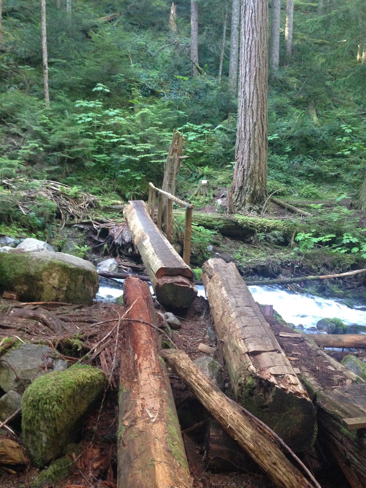
 |
| The log near the split in the trail that allows you to cross the creek to reach the "trailhead" of Mount Grant. There's a pile of debris to the right of this log (not in the photo) that I used instead due to high water levels. The risk of having two wet shoes was not part of my plan, so I opted for the easy way out. |
From this point forward the trail becomes ridiculously steep. The switchbacks are gone, it's all straight up now. Not before long you're in the open, scrambling up the ridge of Mount Grant. For reference, for those who have hiked Williams Peak, think of the scramble to the summit and multiply that by 2. I describe it as a relentlessly steep, often requiring use of your hands to stabilize yourself. Also known as, a pain in the ass.
 |
| A little pond just before exiting the forest. Too bad it was infested with mosquitoes. I had bug spray on, but they didn't give a damn about that. |
 |
| Hiking in the early parts of the summer is like time travelling. As you go up in elevation you get to see multiple seasons. Here we have a few plants just making their way out of the ground. Down in the valley, these would've been in full bloom. |
 |
| No more trees to shade you from the sun. (hint hint) |
 |
| The odd cairn to give you reassurance that you're on the right route. |
 |
| Photos don't do the steepness justice. |
 |
| An American marten who seemed very perturbed by my presence as he was munching on his catch of the day. Or maybe he was just confused by the fact that I was having a conversation with him...the sun was starting to get to me. |
 |
| First view of my surroundings once I got above the tree line. Eaton peak is the prominent peak on the left, towering over the south side of Eaton lake. In the distance we can see some of the peaks of the Chilliwack River Valley. |
Exiting the tree line marked the beginning of the end for me. With temperatures soaring to 36 degrees celsius in the valley, the sun was also absolutely scorching on the mountain. Not to mention, the absence of even a slight breeze, which made it extremely difficult to stay cool. My pace slowed down incredibly, the sun slowly draining my energy. After a while I was taking a pause after every 5-10 steps. It was the warmest and the steepest part of the hike. My frantic pace through the first half of the hike had finally caught up to me. My legs were now heavy as I was willing myself up the mountain, too stubborn to quit. By the end, I was pretty much crawling my way up.
 |
| From this point forward, the marking tape was barely invisble. I followed the gully/stream to the left of the photo. The snowy gully to the right was a little too steep and very slippery. |
 | ||||
| "The gully to the left" in the previous photo. The footing was quite challenging. Again, the photo doesn't do it justice on how steep this really was. |
 |
| A view of the ridge up ahead. Turns out I was still no where near the summit. Luckily, I found a few old pieces of marking tape on some of the little trees on my way up, which kept me motivated. I was in really bad shape when I took this picture, I knew I didn't have much left in the tank and I was considering turning around. |
After that last photo, I stopped taking pictures for a while. I was really losing focus, spotting marking tape had become increasingly difficult. I drapped a spare t-shirt that I had in my bag over my head to shade me from the sun, but it wasn't enough. About 30 minutes later, 50-75 metres of elevation from the summit, I slipped and fell on my butt on a patch of snow and that's as far up as I got. My legs were jell-o, I could barely get back up. I was in a full state of heat exhaustion and I knew if I pushed any more I would put myself in a situation where getting down would be nearly impossible. I sat there throwing snow all over myself as I ate my lunch. Thirty minutes passed by and I was still feeling terrible. I was able to see the summit, I was so close, but I just couldn't do it. Giving up for me was the hardest thing to do, but at the same time it was the smartest decision I made all day. I did get some reward for my hard work though. The views from my lunch spot were still incredible.
 |
| I was right there, 20 minutes away from 360 degree views. |
 |
| View to the South - Eaton peak, with Payne, Redoubt and Silvertip in the background. (See the next picture for more details) |
 |
| This is screenshot from a great app I downloaded called "PeakFinder Earth". It even works offline, therefore I use it on all my hikes. It is also a great tool for always knowing where you are. |
 |
| View to the Southwest - You can faintly see Mount Baker, the biggest peak covered in snow in the center of the screen. From this vantage point I was able to spot most of the peaks I've climbed so far. Truly is a very good representation of my playground. |
 |
| Once again I tried to find a good screenshot representing my photo. Mount Baker is the big unidentified peak in the center. I couldn't get it's name to pop up while being zoomed out. |
 |
| To the west I had a great view of Swanee lake, an adventure waiting to happen. From what I've read, it's an overgrown trail that has turned into a bushwack, a must! |
 |
| To the west again, we have Isolillock towering over the other mountains in it's vicinity. (Another peak on my bucket list!) |
Now for the way down, let's not talk about that much. It sucked. That basically sums it all up. I was so exhausted I struggled with footing. Many breaks were taken and lots of snow was dumped down my shirt and on my neck. Once I got back into the tree cover, I slowly starting recuperating. I still felt really ill, but I finally was starting to get my energy levels back, which made dragging my ass down much easier from that point on.
 |
| The only good part about the way down was foot skiing down these patches of snow. It saved bundles of time. |
 |
| A long way to go. |
All in all, Mount Grant turned out to be an adventure to remember, mostly for all the wrong reasons. I will conquer it by the end of the summer, that's a guarantee. Hopefully it will be a day with much milder temperatures and many more hikes under my belt.
I made many tactical mistakes on this hike but I ultimately made the right decision in the end. I have no doubt my furious pace up to Eaton lake came back to bite me in the butt. Hydration and nutrition could have definitely been better. I was sweating so much due to the humidity, therefore, I was losing so much sodium without replenishing it. My solution to that was to keep drinking water, but really I should've snacked earlier instead of planning to eat my lunch at the summit. I truly believe if I would've made one final dash to the summit, I would've had nothing left for the way down.
This brings me back to the start of this post. KNOW YOUR LIMITS. I like to push my limits, always have, as I did this time. The only positive from this is that I knew when I was at my maximum threshold, I listened to my body and I stopped. As a reminder for all my fellows hikers, pace, hydrate and fuel yourself according to your fitness level and always know your limits. The mountains won't go anywhere, you can always try again another time...but only if you're still alive.
On that note, I will sign off. Thanks for reading, don't be afraid to leave a comment!
Until next time,
Eric
Subscribe to Hiking with Eric by Email
This is now my favorite blog, next summer i'm coming down to make an appearance on one of these. Absolutely beautiful, keep it up buddy!
ReplyDeleteThanks man, I appreciate it! You come down, and I'll gladly feature you in one! You know you're always welcomed here.
DeleteGreat write up Eric! May all your future adventures be exhilarating and eventful,..and I'll keep reading! ;)
ReplyDeleteThanks for reading! Glad you enjoyed it. I hope they can all be this exhilarating, but for reasons that will be a little easier on my body next time! haha.
Delete